Historic Sites along Ebbetts Pass
The foothills around Ebbetts Pass were settled early in the Gold Rush. Murphys became an important mining community along the Mother Lode, generating millions of dollars in gold. Soon afterward settlers began to spread east into the mountains, seeking timber and grazing lands. The discovery of the giant Sequoias in Big Trees added another dimension to the region's businesses - tourism.
By 1856 Calaveras County joined other communities up and down the Mother Lode by establishing their own road across the Sierra. The emigrant route, which was more trail than road, left the heavily used Carson River Trail in Hope Valley and swung south across Border Ruffian Pass and down into Hermit Valley before turning west to Murphys. A decade later the Carson Valley and Big Trees Turnpike was built across today's Ebbetts Pass.
Gold Rush Era Towns
Murphys
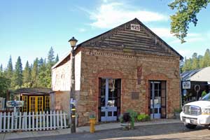
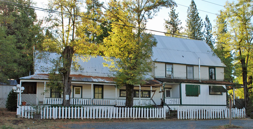
Murphys was founded in 1848 by brothers John and Daniel Murphy, members of 1844 Stevens-Townsend emigrant party, the first to cross Donner Summit. The Murphy brothers built a trading post and established a gold mining operation which produced about two million dollars-worth of gold. Soon others rushed to the area and by 1850 the population of Murphys reached 1,200. Gradually tents were replaced by wooden stores and shops and those, by fire-proof stone buildings. Walking Tours of historic Murphys are offered on Saturday mornings at 10:00 AM, departing from the Miners' Museum.
Mountain Ranch
Nine miles east of San Andreas, Mountain Ranch is a small community that established its roots during the Gold Rush. Several historic post offices and an old hotel can be seen in the town. A historic marker there describes the significance of nearby California Caverns.
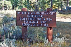
Silver Mountain City
Along Silver Creek on the east side of Ebbetts Pass Silver Mountain City was once a thriving mining community. It was first called Kongsberg in 1858 by early Scandinavian miners. Later Silver Mountain City became the Alpine County seat from 1864 to 1875. When news of rich ore deposits in Bodie reached Alpine County in 1878, the last residents of silver Mountain City rushed off to try their luck at the new strike.
William Brewer described his visit to the town in the 1860s: "There are perhaps forty houses, all new (but a few weeks old) and as bright as new, fresh lumber, which but a month or two ago was in the trees, can make them. This log shanty has a sign up, 'Variety Store'; the next, a board shanty the size of a hogpen, is 'Wholesale & Retail Grocery'; that shanty without a window, with a canvas door, has a large sign of 'Law Office'; and so on to the end."
Today there are few remnants of the mining town. After it was abandoned, most of the buildings were moved to Markleeville. A sign indicates the location of the old stone jail, its remnants guarded now by a fence. Farther east are the Chalmers' mansion and smelter with its distinctive chimney, and the Chalmers family cemetery.
Mount Bullion
Mount Bullion was an early mining town located at the junction of Monitor Creek and the East Carson River. Settlers there were hopeful that the region would blossom into another Comstock. Joseph Holbrook Coulter worked as a mine superintendent in Mount Bullion in the 1870s. Miners included Francis Ashbury Jones and Oscar Fitzallan Thornton. Benjamin Kincead operated a trading post. Today little remains of the small settlement.
Markleeville
Markleeville was first settled by Jacob Marklee who constructed a toll bridge across a Carson River tributary in 1861. For a time Markleeville was just a few scattered buildings, but after Silver Mountain City collapsed as a key mining community, Markleeville was given the title of county seat for Alpine County in 1875. As mining began to wane in the area, lumbering and ranching took over as the main industries of Alpine County. The Markleeville Museum on school street has exhibits and historic buildings on display.
Early Settlements along Ebbetts Pass
Calaveras Big Trees State Park
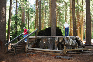
Credit for discovering the giant Sequoias in Big Trees State Park has been given to Augustus T. Dowd who wandered into the north grove while hunting a wounded bear in 1852, although John Bidwell claimed to have seen the trees while crossing the Sierra in 1841. Local businessmen purchased a grove of 100 trees and built accommodations for visitors. Dowd's Discovery Tree was cut down and the stump turned into a dance floor. The history of the park is preserved in the visitor center.
Avery Hotel
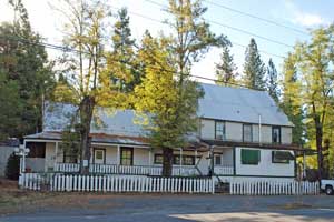
The Avery Hotel was built along Moran Road, which was the main corridor for travelers between Murphys and Big Trees. The site was first settled in the 1850s by Joseph Manly Goodell of Murphys and his wife Sarah. Later the hotel was purchased by the Avery family. George Avery had been a hotel keeper in Copperopolis in the 1870s. They operated the Avery Hotel for many years, serving stage coaches, freight wagons, loggers, and drovers. In more recent years it was converted to a resort. The hotel is now closed.
Dorrington
The Dorrington Hotel was constructed in 1852 by John and Rebecca Dorrington Gardner as a stage stop for travelers using the Big Trees Carson Valley Road. When a post office was established there, Rebecca's maiden name was used because there was already a Gardner post office in California. The hotel also was a popular summer destination for visitors from lower elevations wanting to enjoy the salubrious mountain climate.
Camp Connell
Camp Connell was established in 1929 by John F. Connell who built a store, campground, and cabins in 1928 to serve travelers and tourists who were flocking to the mountains in the summer. A post office was opened there in 1934. The campground closed in 1949. At one time there was a short ski lift running up the mountain behind the store.
Cottage Springs
Cottage Springs was homesteaded in 1865 by A. Henry Stevens, and then was taken over by the Gardners. A tollgate was established there along the Big Trees and Carson Valley Turnpike. In more recent years a small ski area was built on the slopes across the highway by the Miller family. For a number of years it was a popular stopping place for beginning skiers and for sliding on an adjacent hill. The ski area has now closed and all the lifts have been removed.
Ganns Homestead
Located 10 miles east of Camp Connell, Ganns Homestead was claimed in 1902 by Charles Albert Gann. Property near the homestead was divided into a housing tract, but as it turned out some of the lots were on Forest Service land. Stone cabins across the road from today's dilapidated Gann's Inn were part of the old Bailey's Resort from the 1920s, which burned down.
Tamarack
Tamarack was originally called Onion valley and was used as summer range in the 1860s and 1870s. C. Brown established a sawmill there. Willger H. Hutchins of Murphys built a store and dance hall there in the 1920s and gave the location the new name of Camp Tamarack. Later the main building burned. Subsequent owners built a lodge and operated it as a resort for summer and winter visitors.
Historic Places
Big Trees Emigrant Trail
The Big Trees Emigrant Trail was established in 1856 and only saw light use during its several years as an emigrant route into California. An exploring party from Murphys surveyed the route and then work parties built bridges across some of the key river crossings. It's two passes - Border Ruffian and Pacific Grade Summit - were a thousand feet lower than West Pass on the Carson route. A better road built over Echo Summit soon captured the bulk of the trans-Sierra traffic.
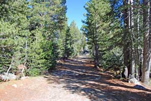
Traces of the trail are hard to find now. One of the best sections runs from below Cape Horn down to Lake Alpine. The trail crossed the valley (that was later inundated by the lake) and wound down to Bear Valley. The Alpine to Bear Valley portion of the trail is well marked on maps. Another section of the trail is the route from Hermit Valley to Blue Lakes.
The Carson Valley and
Big Trees Turnpike
When the Silver Mountain mining district boomed in the 1860s a road was constructed from Silver Mountain City up the north side of Silver Creek. It joined today's modern highway 1.8 miles east of Kinney Reservoir. Today the 2.5 miles of the turnpike on the far side of Silver Creek are labeled as Forest Road 1112. Much of the old turnpike was lost beneath today's Highway 4, but a nice section of the early road can be found on the west side of Pacific Creek between Hermit Valley and Pacific Valley.
Scossa's Cow Camp
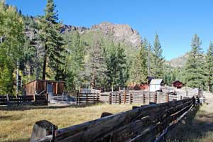
The corrals and old buildings along Silver Creek on the east side of the pass always catch people's eyes as they drive by. The Scossa family arrived in California from Switzerland in the 19th century, homesteading in Diamond Valley and working as lumbermen hauling "packwood with mules." John Scossa married Snowshoe Thompson's widow. The Scossas have been running cattle in Alpine County for generations since.
Chalmers Mansion and Cemetery
The distinctive brick smelting chimney along Highway 4 marks the old Chalmers mansion. It was built by Lewis Chalmers who was superintendent of a mine in the Silver Mountain mining district in the 1870s and 1880s. Chalmers and his brother John came to California from Scotland. Lewis returned to Britain in 1885 to raise money for his mining operations, but he never returned and died there in 1904. Several of the Chalmers family are buried in a small cemetery along the highway not far from the house.
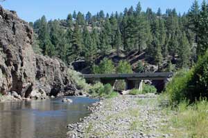
Hangman's Bridge
Hangman's Bridge, where Highway 89 crosses the East Carson River south of Markleeville, gained its name when vigilantes hung Ernst Reusch there in 1874. Reusch had shot and killed E. H. Erickson, whom Reusch believed had been carrying on an affair with his wife. The old bridge was long ago replaced by more modern highway bridges.